#29: Complete blog guide to Irshalgad fort trek
Irshalgad rises to an elevation of 1726 ft. (526 m) above MSL in the Matheran range. It was used as a watch tower to keep an eye over the region between Manekgad and Prabalgad in its heydays. The Irshalgad trek is famous for its unique Nedhe (a hole carved into a block of rock due to constant battering by natural forces over a long period of time) overlooking the Morbe Dam. The climb beyond Nedhe requires technical rock climbing skills and shouldn’t be attempted by amateurs. The following blog post describes the trek to Irshalgad Nedhe with my friend Rohit in the monsoon season, along with other essential information that would help the readers attempt it themselves.
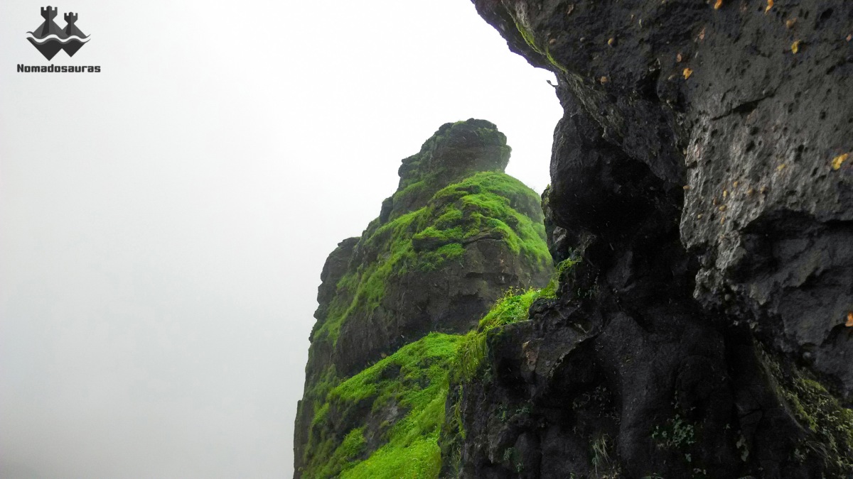
Table Of Contents
Essential Information about Irshalgad trek
Trek map
Trail directions & Travel information
GPX file of the trek
Disclaimer
Backstory of the trek
Trek day
Additional pictures of Irshalgad trek
Epilogue
Note to Reader
Know Before You Go For Irshalgad trek
Where: Irshalgad fort
Type: Hill trek
Height: 1726 ft. (526 m) above MSL.
Total Distance: 11 km (to and from Chowk bus stop).
Average Duration: 6 – 8 Hours
Hill Range: Matheran
Base village: Irshalwadi (18°55’57.22″N, 73°14’3.97″E) & Nanivali (18°54’41.06″N, 73°14’29.11″E).
Nearest railway stations: Karjat (Central Railway) & Panvel (Harbour Railway)
Difficulty: Difficult for beginners & Moderate for experienced trekkers in Monsoon.
Endurance: 3
Risk Factor: Medium till Nedhe & High for Peak. (What do these grading indicate? Find out here!)
Best time to visit: June to February
Travelling expenses: Less than ₹ 100 per head.
Food and Water: Two water cisterns near the Nedhe are the only sources of water on the mountain and they dry up in summer. Carrying adequate water (3+ litres) is advised.
Irshalgad fort trek map:
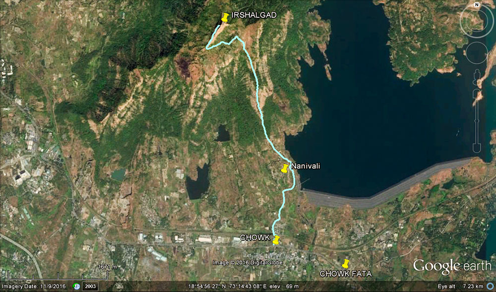
Trek Route
Karjat- Chowk bus stop– Chowk railway station- Nanivali- Irshalwadi- Irshalgad Nedhe & back via same route.
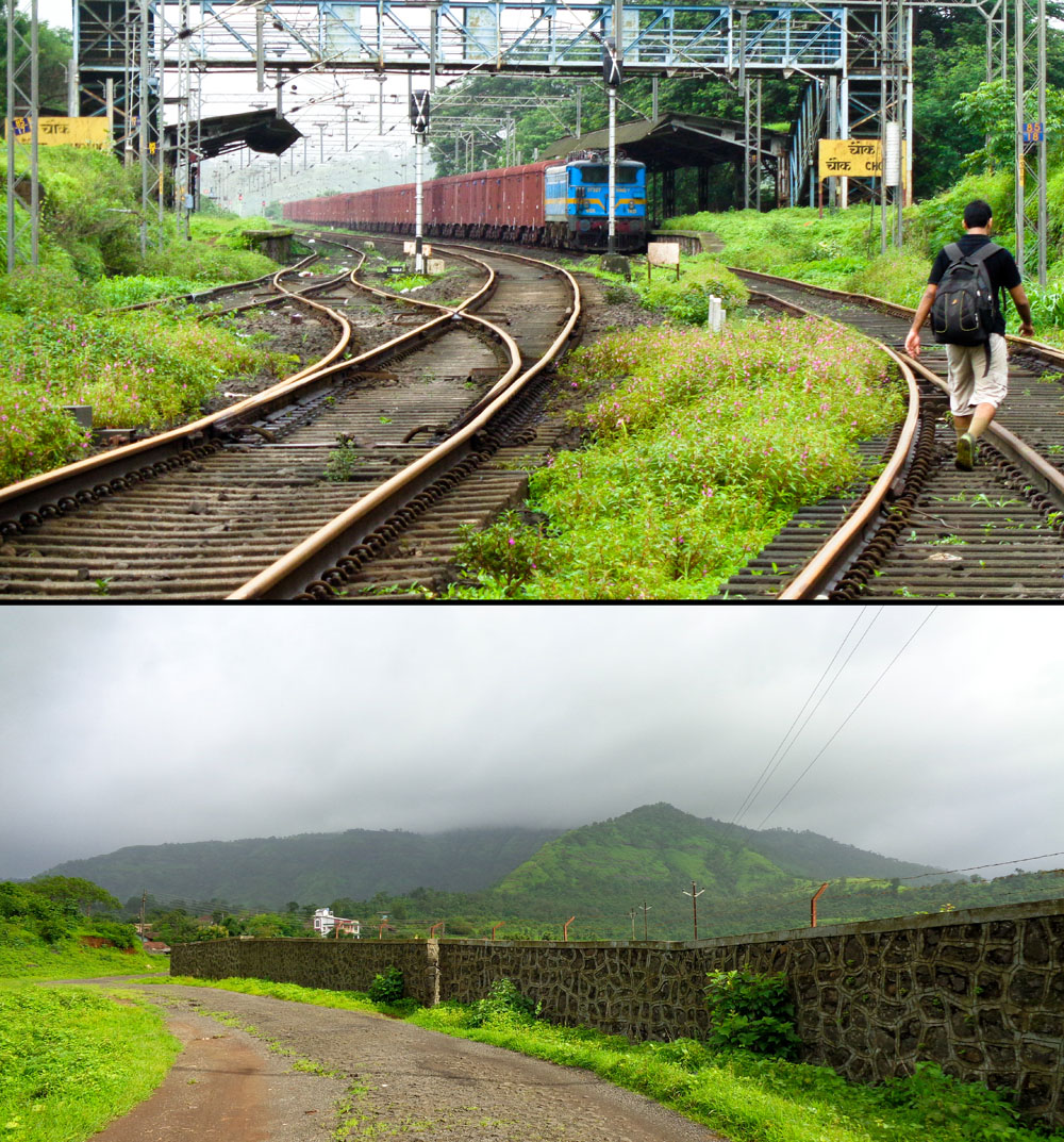
Description: Alight at Chowk bus stop (NOT chowk fata, the station is a km from that stop) & cross Chowk railway station to reach the Morbe Dam road. The trail passes through Nanivali before climbing uphill to Irshalwadi (base village).
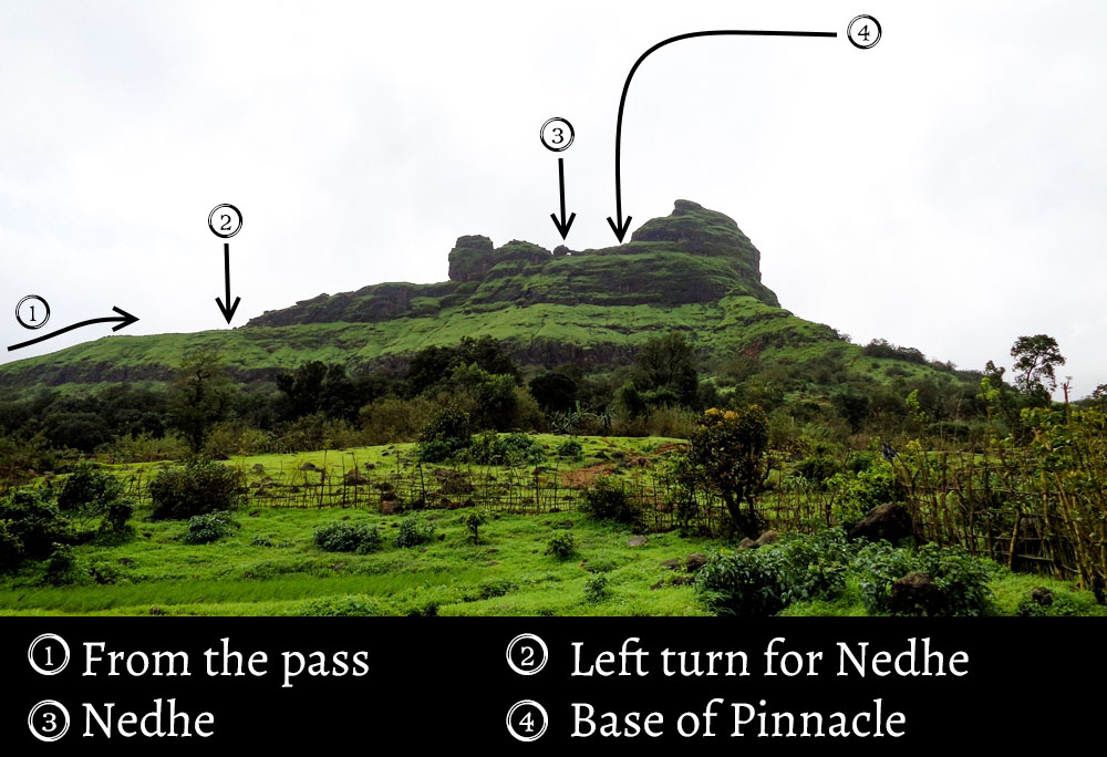
Take the mud trail in south-west from Irshalwadi (keeping Irshalgad to your right) and proceed for 300 m, crossing a temple and couple of seasonal streams along the way to reach a pass. Turn right (usually marked by a shoe/bottle on a twig) and climb the rocky trail to reach the main ridge. The way ahead is up the western face of the mountain. Negotiate a medium grade rock patch & a rickety vertical ladder to reach the Nedhe.
Follow the same route for descent.
Note: You can reach the base of the Irshalgad pinnacle by a narrow, exposed path to the north of the Nedhe. Utmost caution is advised in monsoon as strong winds lash the peak. DO NOT attempt to climb the peak without proper training and most importantly, without proper equipment.
GPX file:
Irshalgad trek GPX file by Nomadosauras on Wikiloc.
Other possible routes:
Irshalgad to Prabalgad range trek: This is a gruelling 20 km trek where one starts from Chowk railway station, climbs up to Irshalgad Nedhe and back to Irshalwadi before proceeding to Prabalgad by a 2 km long connecting ridge at the North. A tricky traverse over the prabalgad plateau (maal) leads you to the Poinje col, from where one can ascend Prabalgad via the route known as Poinje South ascend (aka Chincholi Vaat) or continue west to reach the southern Prabalmachi hamlet and then continue to Thakurwadi or Vardoli. I did this route in Monsoon ’17 and the guide is essential as the trail is often hidden underneath overgrowth during Monsoon. A young lad from Irshalwadi, Sunil Pardi (Contact # 8412824190) led us all the way to Prabalgad. He can also help you with the ascend to Nedhe if there are are first-time trekkers in the group.

NOTE:
- The information provided in this post is for informational purposes only. Any reliance you place on such information is therefore, strictly at your own risk. Read complete disclaimer- Terms Of Use.
- All the pictures used in this post have been clicked by me or my friends, unless stated otherwise. Content (including images) not for reproduction in any form, partial or otherwise. For commercial use of Content from the post, please send a message using the Contact form.
My tryst with Irshalgad
I first laid my eyes on the boat shaped pinnacle of Irshalgad while passing through Irshalwadi back in July ’15, on our way to Matheran by the Pisarnath ladder route. Later I looked up every available piece of info that I could lay my hands on and one thing was certain: the final climb to peak is very dangerous. And when Harish Kapadia sir (Author of ‘Trek the Sahyadri’) describes the trek as one that demands caution, you better pay heed 😛
On a more serious note, the final climb to the peak is notorious for casualties (atleast a couple of them have been documented: One in the 80’s and another one in the last decade. Memorial plaques have been fixed at the base of Nedhe & pinnacle in their memory) and best left to trained professionals with proper equipment.

So, I and Rohit finally decided to hike upto the Nedhe (easy in winter and moderate grade in monsoon), last August. We have been friends since College and are always looking for thrilling experiences. A very hectic week leading up to the trek meant I had slept less than 4 hours in the last two days and this made the trek, for me at least, a lot more challenging.
Trek Day
One of the things I love about trekking with Rohit is that he’s always game for an early start and this time was no different! We boarded the 4.48 am CST-Karjat local train, alighted at Karjat at 7.15 am and crossed over to the east side to enquire about the transport options.
Note: Tum-tums which operate on seat sharing basis, charge you ₹ 20 per seat whereas Panvel bound buses will drop you off at Chowk bus stop for ₹ 14 per seat.
We were busy paying for a samosa at the only hotel open that early when I heard the distinct rumble of the Laal dabba (that’s what the iconic red coloured bus of the State Transport is locally called. It’s fast & uncomfortable but more importantly, there are very few places it won’t go to in Maharashtra 😛 )

Now this remains one of the few instances when I had a bad experience with an S.T bus conductor cos usually, if you are polite with them then they are really helpful.
We had requested the conductor to let us know when the bus is about to reach our stop, which is a common practice in S.T buses. About 15 mins later, we alighted at what, according to him, was the Chowk bus stop. It was only after the bus had passed that I noticed we were at the Chowk fata (the junction where Karjat-Murbad road meets NH 48), which is a good kilometer away from Chowk bus stop. I checked the ticket and to my dismay found that he had fleeced us by handing us tickets to some random destination, the fare for which was a mere 2 ₹ despite charging 14 ₹, which is the fare for Chowk.
Now in case you are wondering, No, the money isn’t the issue here- 12 ₹ is petty change in today’s time. What hurt me was the fact that he had conned us and on top of that, knowingly made us alight at an incorrect stop.
I have since made it a point to check bus tickets thoroughly. It is indeed unfortunate that the goodwill built by numerous public employees over so many years is lost because of a single black sheep ![]()
Anyways, putting behind the unpleasant experience, we started walking along the highway but soon found out that it ‘ll be safer to walk along the very rarely used Karjat-Panvel railway corridor instead of the road, swarming with speeding cars 😛

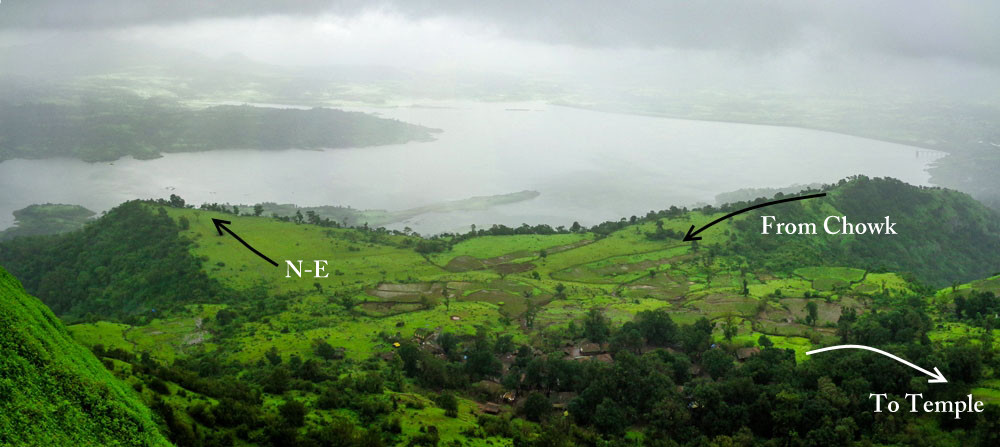
The hills were enveloped by fog but the trail to Irshalwadi was clearly visible all the way from Chowk fata. We crossed Chowk railway station around half past eight and took the Morbe Dam road to Nanivali, a tiring walk of 1.5 kms on the paved road.
As mentioned earlier, the trial splits after Nanivali and we took the uphill trail in the North-west (slight left) while the broad trail in the North (slight right) passes through a 5-odd km stretch of dense forest to end at Arkaswadi, the base village for Pisarnath ladder trek to Matheran.
The trail zig-zags through the steep section of the hill and flattens out on the narrow section of the ridge before entering Irshalwadi. I had started feeling drowsy by then due to lack of sleep and I voiced my aprrehensions to Rohit. There was no point in putting Rohit at risk by continuing the trek when there were chances of me becoming a liability later on in the tougher sections but he would have none of it- Rohit was sure I could pull it off when I wasn’t sure myself! If it wasn’t for his constant encouragement, I probably would turned back from there. I didn’t thank him back then but I ‘ll make amends here. Thank you, Bro! 😉

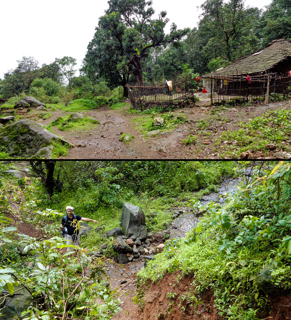
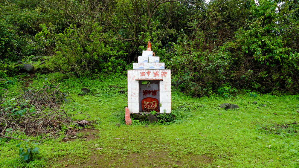
The boat-shaped pinnacle of Irshalgad was still obscured by fog when we reached Irshalwadi at a quarter to 10. After confirming the path with a kid from the hamlet, we took the mud trail in south-east (keeping Irshalgad to our right) and crossed a seasonal stream in 5 mins’ time followed by the temple of Vishaladevi.
Note: When we were ascending in the morning, the visibility was barely 15 feet and hence, most of the pictures posted below were clicked while descending when the fog had dissipated.
Note: I was carrying a map made from the only GPS trail of Irshalgad trek available on wikiloc back then. It is correct save for the part I ‘ll mention below. You can download my GPX trail of the Irshalgad trek for easy navigation on the field.
We jumped over another seasonal stream to reach the ridge. There was a trail on our right going up the ridge, meandering through boulders but the map we were referring to, indicated that the correct trail will turn right after some more distance. With the visibilty down to barely 15 feet, I thought it best to stick to a known route (little did I know that the ‘known’ route we were embarking on, was the route most people end up getting lost on!) instead of finding a new one.
Barely 200 metres from the pass, the trail ended abruptly at the fence of a field and perplexed, we looked around for a farmhand to help us with the route but found none. I fished out my cellphone once again to check our location on Endomondo and guess what? The app had crashed! ![]()
With no internet to reload the in-app map (offline map option does not support satellite imagery), we had to rely on our sense of direction to find the way out. We looked around and inferred that we were still on the supposedly correct (i.e. the incorrect) path. Attributing the absence of clear trail to the incessant rain, we decided to proceed and find a way by circumventing the field. BIG MISTAKE. Despite knowing that a rarely used trail on a well-frequented mountain most often implies that you are lost, I went ahead only due to the map. After 5 mins of hacking our way through overgrown plants, we reached a small stream flanked by deep mud on either side and we looked at each other. We were lost.

I was trying to remember if any blogger had mentioned being in a similar situation at Irshalgad when Rohit suddenly heard voices from the mountain (which was a miracle considering we were standing near a deafening stream! Or maybe, the people up the mountain were just really loud 😛 ). We had been the first ones at Irshalwadi in the morning and nobody had passed us either, which meant the right turn at the pass had to be the correct path!! DAMN!
We carefully started making our way back through the foot-deep mud and reached the pass. When we had crossed it earlier, the visibility was so low that we had failed to notice a twig on the left side, with a small bottle hung on it pointing right, as a marker for the turn.

Note: Always ask the villagers if you are unsure of the route and if you can’t find any, trace back your path instead of forging a new trail. Chances are that you are lost and trying to persist will land you in deeper trouble.
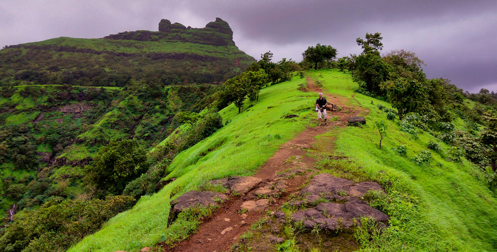
We negotiated an easy rock patch after taking the uphill trail on the right and soon we were on the main ridge staring at the famous pinnacle straight ahead!

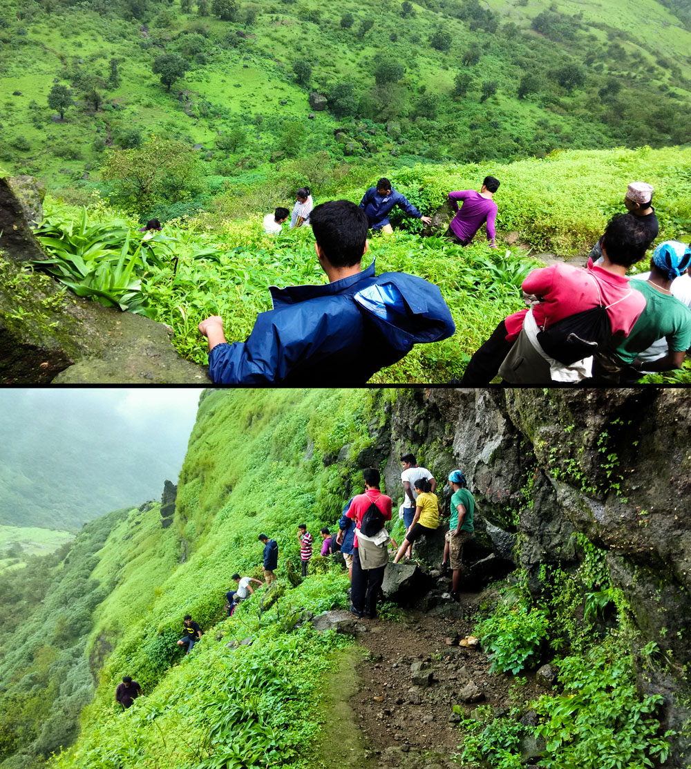
We saw a couple of guys disappearing into the bushes (no pun intended 😛 ) on the left (western face of Irshalgad) of the pinnacle cluster and promptly followed them. The overgrown bushes had actually hidden a trail that gradually turns into a narrow, zig-zag path that climbs steeply over the western face.

The final stretch of the trail consists of several small rock patches and a ladder fixed over a slightly tricky portion.
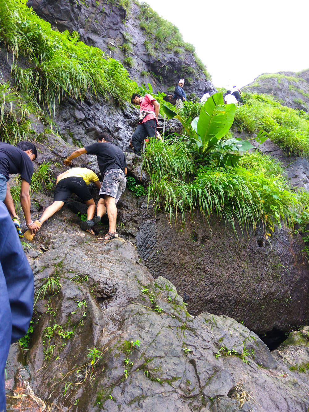
The 20-odd strong group in front of us was being guided by 2 villagers from the wadi who were helping them climb as well. The constant drizzle and slippery rocks had rendered the holds useless but what’s a trek if you can’t help each other? I cupped my hand and gave Rohit a firmer footing as he went up first and then he gave me a hand over the tricky portion! 😀
Once you cross the ladder, you can find a small depression on the left just beneath the Nedhe wherein lies the original idol of Irshalkarni devi.

We reached the Nedhe at 11.45am and boy! It was surreal!
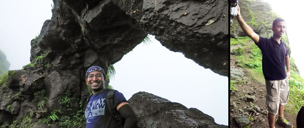
The valley below was playing hide and seek with the fog clearing up for a few seconds to give us a clear view before engulfing it once again.
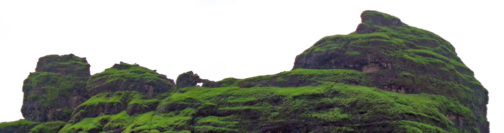
A very narrow, exposed trail crosses the Nedhe to emerge on the eastern side and turns north towards the base of the highest pinnacle. Here’s a picture of the dreadfully exposed pinnacle–

After spending 15 unforgettable minutes in the Nedhe, getting our faces pricked by the the needle like water droplets, we began our descent.

Here are a couple of pictures clicked while we waited for our turn:
There were 5-6 first timers in the group which considerably slowed down our descent as well. Nevertheless, we took the opportunity to converse with the experienced back-leads of the group. I told them about my plans of trekking to Prabalgad & Kalavantin Durg in the following winter but they suggested visiting them in monsoon itself (and weren’t they right!! Both hills transform into mighty monsoon beasts but also reward you with unparalleled experiences 🙂 )
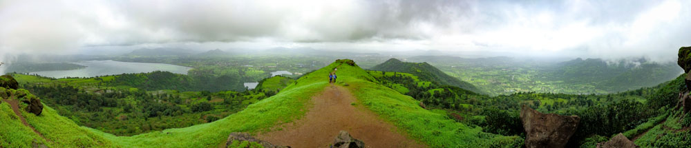
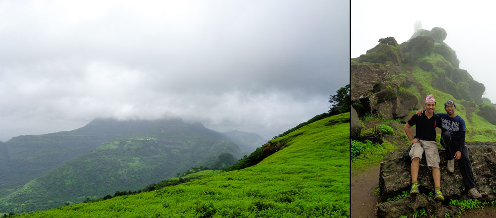
It was half past 12 by the time we came back to the main ridge and opted to stay back while the group continued their descent to the wadi where they had kept their bags. The downpour thankfully stopped after a few minutes and we were treated to awesome views of Matheran, Prabalgad & Sondai! Karnala and Manekgad though, were not visible due to the clouds.
Soon a steady stream of trekkers started making their way up and we directed them towards the trail for Nedhe. About an hour later, we started our descent and passed Irshalwadi in another 20 mins.
Here’s a clearer picture of the Pinnacle–
The rest of the journey was quick and routine except for a few photostops here and there.
AND we saw this cute litter of very young puppies in Nanivali. Their mother was dozing off every few seconds but then would wake up with a start at the thought of her vulnerable ‘pink nosed’ pups! Adorable! 😀

We crossed the railway station at 3 pm and boarded a bus for Karjat. Despite the driver trying to fulfil his F1 aspirations on the excellent Karjat-Murbad road, we missed the train for CST by a few minutes and so, took the opportunity to have a quick lunch in a nearby hotel before the next train arrived half an hour later.
To view additional pictures from the trek, check out the Irshalgad Flickr album.
Epilogue:
Irshalgad had always mystified me. The unfortunate history of the place coupled with the unique topography struck fear and awe in equal measures. Multiple canned plans, less than ideal physical condition during the trek, incorrect reference map and getting lost in the forest! Everything seemed to point to one thing – turn back and try another day.
But there’s this quintessential line by Rumi which seems to make sense of the coincidences which conspired to help us climb it:
Maybe, just maybe, the Mountains seek You as well.
I hope you enjoyed reading about the Irshalgad fort trek. Please let me know your thoughts in the comment section!
If you have any questions about Irshalgad fort trek or suggestions to improve the website, feel free to get in touch using the Contact form. I’ll respond as soon as possible 🙂
If you liked the post, please Subscribe to ‘A Season Of Mountains‘ by entering your email ID in the box below and get notified the next time I publish a new post!
Keep Trekking!

Really well described and informative. Will not find stuff like this in travel guides or the internet.
LikeLiked by 1 person
Thank you so much! If it wasn’t for your encouragement, I probably wouldn’t have updated them regularly 🙂
LikeLike
I don’t remember seeing the Nedhe. Maybe missed it as I was the last one to climb up as I was busy clicking pictures. Haha!
About your post, WOW! So detailed and well compiled that I could go this trek again but all by myself and not get lost. I have a lot to add on my next trek blog post. Thanks for the inspiration.
LikeLiked by 1 person
Thanks a lot for the kind words! They ‘ll inspire me to buckle down and update a few more pending posts!
Cheers 🙂
LikeLiked by 1 person
Detailed account of what seems to be an exciting adventure! Feels like rushing there next moment! Super stuff!
LikeLiked by 1 person
Thank you so much for reading! I am glad it made you feel like visiting the place 🙂 Have you trekked in the Matheran Range as yet?
LikeLike
Only once. But not proper trek yet! Would like to join you in near future if possible
LikeLiked by 1 person
I would be glad to have your company!
LikeLike
I have been searching for a blog like this with the detailed description.I feel like I’m one among you guys in the trek.Very very well written.
Waiting for more posts 🙂
LikeLiked by 1 person
Thank you so much! It feels great to know that a reader felt like a part of the trek gang 🙂
P.S. New post will be out in a fortnight or so!
LikeLiked by 1 person
Oh, you had such a wonderful trek and your post so well describes every detail. The pictures are awesome and entices me to take this trek sometime soon. I loved those adorable puppies. They are really cute and cuddly 🙂
LikeLiked by 1 person
Thank you so much! I am glad you ‘re looking forward to climbing Irshalgad! And yeah, the puppies were cute and sleepy too! 😁
LikeLike
Great Blog Bro. You have put so much work into it, its evident! This is awesome! Cool Blog Name! 🙂
LikeLiked by 1 person
Thank you so much for the appreciation! Means a lot! You ‘ve a lovely blog yourself 🙂 And yeah the blog name! Long story that! 😀
LikeLiked by 1 person
Your blog is super informative for someone actually planning to visit these places…and yeah #nomadosauras awesome name 😉
LikeLiked by 1 person
Thank you so much! Means a lot when fellow bloggers appreciate a post 🙂 And the name, I am glad it’s sounding less weird by the day! 😉 😀
LikeLiked by 2 people
Your photographs are awesome. Just a look at them and I wish the monsoons were here again, sooner than later.i love the lush greenery and the hills shrouded in mist.
LikeLiked by 1 person
Thank you so much! 🙂 As much as I would like them to, the pictures don’t even come come close to the actual scene 😦
The cool breeze and tiny needle-like droplets lashing your face as the mountain gets enveloped in the fog! It’s magical!
And you’re right! I can’t wait for the monsoons either.. This was 2016. I had grand trek plans for the last monsoon as well but couldn’t manage more than 5 due to injuries, exams and stuff 😦 Will definitely make amends his time round 😉
What’s your favourite monsoon haunt?
LikeLiked by 1 person
My monsoon haunts are nowhere near to the exotic ones you have blogged on. Last year I went on treks with a little known group in Goa called “Off Trail Adventures”. I liked the Sada village in Maharashtra, close to the Goa border.
LikeLiked by 1 person
Aah! I have heard about Sada village from my friends who have been there.. yet to visit it myself though! Some day 🙂
LikeLiked by 1 person
Wow sir, what a way to present an article with such a good precision and guidance loved it….
LikeLiked by 1 person
Thank you so much Adarsh! The way you have described K2S is amazing too! Looking forward to more trek posts from you. Keep blogging!
Cheers
LikeLike
Yes sure sir would love to join you in any adventure if so in future 😀 cheers
LikeLiked by 1 person
Hello sir ,
Nice description about trekk,
Local guide sunil mention in trekk is reliable because we are the group of 22 people & we will stay night in irshalwadi .
He said i will manage dinner + accommodation for you in irshalwadi . So if you have any idea about this man nature ?
LikeLiked by 1 person
Hi Krunal! I am glad to know you’ll be trekking to Irshalgad!
And yes, Sunil is trustworthy. He’s pretty much the only reason my friend and I made it to Prabalmachi safely before dark during our Irshal-Prabal traverse 🙂
But of course, please clarify the charges and the services (dinner, accomodation, guidance, etc) that are included in it beforehand and take general precautions considering you might have females in your group.
If you have any more questions, please use the contact form to drop me a mail, I’ll be happy to help in any way I can!
Cheers and have a safe trek!
LikeLike
Very informative blog. Pardhi guide provides food and tents for camping. He is a nice guy.
LikeLiked by 1 person
Thank you so much! And yeah, Sunil certainly is a nice guy! 🙂
I just read your account of the Irshalgad trek and it’s splendid as well! Cheers & keep trekking!
LikeLike
Wow 💚
LikeLiked by 1 person
Thank you so much 🙂
LikeLike
Your blog is wonderful … also read about prabalgad … do you have any inputs on prabalgad to irshalgad trek
LikeLiked by 1 person
Hi Neeraj!
Thank you for reading the post and leaving a comment 🙂
And yes, I’ll be able to help you with information about Prabalgad-Irshalgad trek. Please drop a message at nomadosauras@gmail.com. Looking forward to hearing from you!
Cheers!
LikeLike