
#06
When: January ‘15
Where: Vikatgad aka Peb fort
Range: Matheran
Route: Neral-Komalwadi-Nakhind pass route-Vikatgad-Dasturi Naka
Nearest railway station: Aman Lodge (Neral-Matheran Narrow Gauge railway): 3 kms from NM 156 marker & Neral (Central Railway): 5 kms from Vikatgad Caves.
Base Village: Anandwadi/Dhaswadi/Komalwadi (All three are in close proximity)
Height: 621 m (approx. 2050 ft) as per Google Maps & 606 m as per GPS.
Total Distance: 12 km (Neral-Komalwadi-Join Nakhind Pass route on col-Vikatgad-Dasturi Naka)
Time: 9 to 12 hours for this route
Approx. expenses: Less than 200 excluding lunch
Best Time: All year (Avoid day treks during October & March-May)
Map:

Difficulty: Medium
Endurance: 3
Risk Factor: HIGH during Monsoon (A Mumbai teen unfortunately lost his life during monsoon ’16).
Medium during the rest of the year. (What do these grading indicate? Find out here!)
Other Routes:
One Day:
1. Neral- Anandwadi/Komalwadi-Vikatgad-Matheran. (Normal route).
2. Neral-Dilkap college-Vikatgad-Matheran. (Normal route)
3. NM 134 (Last road & railway intersection before Dasturi naka)- NM 156- Vikatgad-Matheran.
Two Day Range trek:
- Vangani- Vaghachi wadi-Nakhind-Vikatgad-Matheran (Dasturi Naka)
- Karjat-Varose-Hashyachi Patti-Malang point-Aman lodge-Vikatgad Dilkap college/ Komalwadi-Neral.

For GPS trail of this and other such treks, visit my Wikiloc page!
Important! This blog describes a winter trek through one of the rarely used, longer routes to Vikatgad. A word of caution before you head elsewhere looking for the more often used, shorter route: Consider visiting Vikatgad only if you have done 10+ moderately difficult treks even if you are going with a commercial trekking group. A lot of unfortunate accidents have happened on the fort in the last couple of years and it is best avoided during heavy rains when the exposed trails become dangerously slippery. Read this news article for one such incident. Check out the following forts for easier monsoon treks-
Mumbai: Karnala, One tree hill route to Matheran.
Lonavla: Lohgad, Korigad, Tikona & Tung.
Pune: Sinhagad, Raigad.
Account of the Trek:
Vikatgad (Jan ‘15) was my first actual trek (Advise: Don’t follow our footsteps and head to Vikatgad for your first trek. We were incredibly lucky to come back unscathed. Get experience on easier treks and then head here). This post is the longest that you ‘ll come across on this blog one of the longest and therefore divided into two parts. My objective behind a very detailed account is to take the reader through all the emotions that we, as first timers went through and hence, to experienced trekkers, may seem to exaggerate the difficulty. Indeed, my later visits to Vikatgad have been fairly easy and my blog posts reflect the same. Notes have been added to help the reader avoid the mistakes we committed.
The Gang: Akshita, Aparna, Mansi, Omkar G, Persis, Ruchit, Shruti, Yogesh & Me
PART I
It was 3 pm and we were at the 15 feet rock patch. What should have been an easy trek based on some blogs, was testing us to the limits. We had been climbing for 7 hours and reached a height of 1500 feet but the summit was still 500 vertical feet away.
Me: Have we bitten off more than we can chew?
Persis: I think so too.
This conversation is etched in my memory as if it was yesterday. We should have been at the peak by noon according to the schedule we had made and panic had begun to set in slowly. What if we couldn’t make it to safe ground before dark? There was barely any network in that region. Mental exhaustion has a way of making things seem direr than they actually are.
But we ‘ll come to that later. Let’s start from how it all began! 🙂
The initial plan was to go for a hike along the lines of what I had done in the preceding December.
Omkar, then came up with this suggestion of a proper trek instead of a hike.
“How about Vikatgad?” he asked.
Vikatgad, also known as Peb Killa, is a fort in the Matheran range and may have derived its name Peb from the ‘Goddess Pebi’ at the base of the fort. Historical references indicate that Shivaji Maharaj used the caves on the fort for grain storage.
Omkar had attempted this trek earlier with his friends but aborted it midway after they lost the way without a map to help them out. I asked my classmates about changing the plan to a trek and they were more than eager. So I read some trekking blogs to collect information about the route and even found a traced path on Wikimapia! woohoo! THE TREK WAS ON! (Here is a list of some excellent links to get information about prospective treks)

As has become the norm now, a plan isn’t a plan unless a new WhatsApp group is made for it 😉
So the group was made and members were added, a high-res map was made (whatever I could manage with my crude Photoshop skills back then), a list of stuff that we’ ll require was compiled and a restless night later, the day of the Trek was here!
Trek Day!
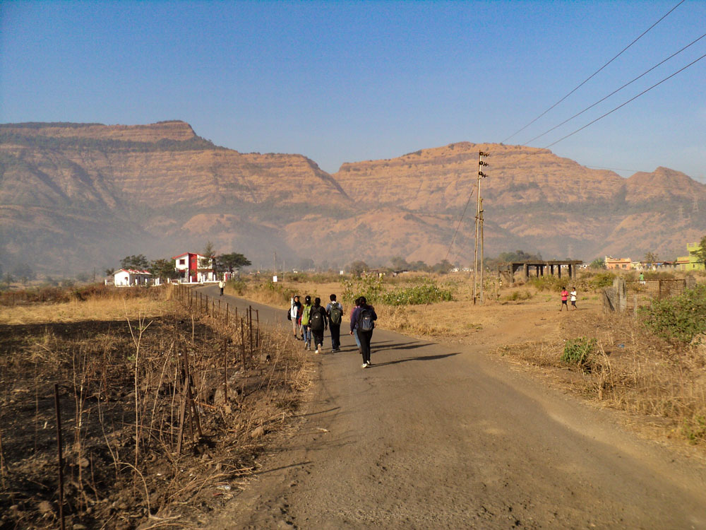
Some people backed out the previous day and Yogesh (without whom I don’t think we would have made it back in time) jumped on the trek bandwagon at the last moment (Literally! He was about to miss the train from Kurla!) and the party reached Neral by 8 am.

We took a right turn from Neral (east) ticket counter (Left goes to Matheran via Dasturi Naka) and a quick breakfast followed in one of the many restaurants that line up the station road. Cross a bridge and the second left takes you towards the Neral-Badlapur road.

There are two routes to the base hills of Vikatgad- One goes through Anandwadi and the other goes through Dilkap college boundary. You can see the Dilkap college across the road and a bridge on the left.

We turned left upon reaching the road and then took the first right after the bridge. Our first landmark was Mohachiwadi-

Base village for Vikatgad is Anandwadi, the way to which is through a broad tarred road from Mohachiwadi. People wanting to cut down the walking distance can take an auto directly till the base village for less than 100 bucks. But we were a cash-strapped lot and besides, what’s the fun in breezing through the roads cocooned in a vehicle when you could as well enjoy the scenic walk? It takes less than an hour to reach and is a pleasure, especially during foggy Monsoon mornings!
The map we were using indicated a right after reaching Anandwadi. About a km before the base village, we saw a small hamlet which is known as Komalwadi.

Taking the right towards the wadi, we reached a dry river bed in 10 mins and criss-crossing through the numerous fields that dot the landscape on the other side of the bed, we made our way to the foothills of Vikatgad.

Just as were approaching the foothills, we walked into the boundary of some villager’s cow-shed. Unable to find a way out and looking around like headless chickens brought a good Samaritan out of some nearby hut and he promptly showed us a detour around a field which was the way to climbing the base hill and onward to the electric tower with a big cement base. (If you are going in monsoon, the overgrown grass can make it tough to find the path- remember this, you climb the hill to the right of the first elevated tower)
Slowly we started climbing the hill and two key differences between my December rail hike and this trek struck me:
ONE- The short steep climbs can leave us couch potatoes breathless.
TWO- You have to find your way unlike the hike where you just blindly follow the tracks to Matheran, so this is a little tough mentally as well.
Since none of us had ever trekked before, save for Mansi and Yogesh, we were struggling and it was Mansi who came up with the idea of picking up a stick to assist in climbing.

Soon we reached a tower with a huge cement base and climbed a little further onto a thinly forested plateau where we came across some villagers on their way back after collecting firewood. It’s a good practise to always confirm whether you are on the right route with villagers whenever you get the chance coz here in Sahyadri, the localites are your google maps! 😛
Doing the same, we marched ahead not knowing that this was going to be our last brush with a fellow human being for a good 7 hours. Crossing the forest, we reached a clearing from where one can clearly see the Vikatgad.

For the Normal route, cross three elevated towers and then you take the path ahead that goes straight from the clearing towards the point shown in the earlier pic. On this route, a prominent landmark is a hollow tree you come across after some distance from the clearing before entering the forest and climbing up a dry waterfall to the left-most col on the ridge.
This is where missed our path for the first time. A lot of blogs advised following the tower route and we did so quite ‘literally’. It’s always prudent to use your instinct and not take a bloggers version to be the last word. (The irony! I know 😛 )
NOTE: Sahyadri is home to a dynamic culture and the people in the villages use different paths to reach a certain place, sometimes out of convenience and sometimes out of necessity (e.g. wildfires). So you may come across some new paths that weren’t there when someone else visited a particular place.
We took the path on the right side at the bifurcation since the 4TH tower was on the right of the clearing. Even though it did seem like we had lost the way completely, I came to know later that the route we ended up on, is actually a longer route to Vikatgad that people take when coming from Nakhind towards Vikatgad. Here is a post about my later trek traversing the Nakhind-Vikatgad-Matheran.

(This route of ours will henceforth be referred to as the summer route in this post)
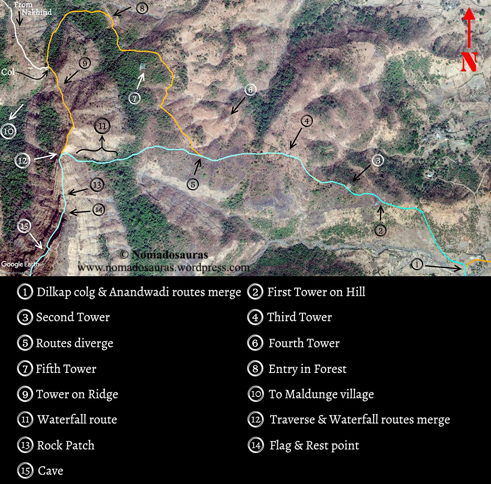
About half hour after crossing the tower lines such that they now lay on our left, we found an opening in the forest on our left that seemed to lead to the col (a depression between two mountains) before the tower on the ridge (landmark 2).

THIS IS WHERE OUR ADVENTURE STARTED! 😉
Taking the forest route which steadily climbed up, we managed to take a lesser used passage and ended up in a path parallel to the correct one.

Making our way through thorns, shrubs and cobwebs (which is enough indication to know you have lost the way), we reached a point where you could see the light seeping through the forest but the path ahead was blocked with wild growth. Not wanting to head back with the col so close, I tried to find a way through to the correct path and after looking around for a couple of minutes found a narrow steep way through trees. It wasn’t easy but everybody found their inner COMMANDO and crouched their way through to the correct path in a manner that would have made Indian Army proud! 😛
The Col was barely 5 minutes from this point and we slumped down to take a breather.

My trusty Samsung Core entered ZEN MODE 😉 and summoned network out of the blue to start pinging with messages from our classmates. Ironically, the first msg I read was ‘Have a safe trek’ on the class whatsapp group that made me smile recounting the ordeal we had just been through in the last hour. But then it’s the intention that matters after all and it remains a sweet memory! 🙂
After getting some Glucon-D (courtesy Aparna who can be seen busy making it in the col picture) in our system, we started towards the tower on the ridge. There are two ways from col. The path that goes down into the valley heads to Dodhani (Base village for the Sunset Point trek to Matheran) and the other one on the left side goes towards Vikatgad. It’s a narrow path and leads you to the tower in 10 mins. The Tower on the ridge, as we had christened it, was our third landmark and its sight barely an hour after thinking we were lost for good felt like a small victory in itself! The grand plans of roaming Matheran after climbing Vikatgad long forgotten, we were enjoying the moments one at a time. 😀

Passing the tower, you see a 25m high 30-degree steep climb up a hill. Ruchit, Mansi, Shruti and me climbed up followed by Akshita, Persis, Aparna, Omkar with Yogesh bringing up the latter part (climbing with his and Aparna’s bag as well). Halfway up the hill, I heard my name. I looked back and told Akshita to go up ahead as I slid down on my haunches towards Persis who was about 6 meters up from the base.

I asked her what’s the matter, and she replied that she couldn’t do it. To be truthful, it wasn’t easy to climb this patch, especially in the first trek. You could see the valley on either side of the ridge with dried plants providing the only cover between you and a 200 feet drop. I told her that going back wasn’t an option. We were closer to Matheran than Neral and I hadn’t been tracking our route on any app so finding our way down the forest was another question I didn’t want to face. The ridge had holds at alternating steps, though only one person could climb at a time.
So I told her that I can’t help her. “Nobody can. Only you can help yourself and You can do it. You have to! There’s no other option”. She looked at the path ahead and said she ‘ll do it. And boy! did she do it! Steadily made her way up like a seasoned trekker. I came down a couple of steps to the place where Aparna was. She was scared of the valley as well. Thankfully, a couple of words of encouragement was all that was needed and she made her way up as well without any help.
Omkar had frozen some feet from where I stood and said he’s scared of heights.
My jaw dropped. I was like you had said you don’t know if you are scared of heights when I had asked before the trek and pat came the reply which is one of the best-remembered lines from the trek: “EVEN I FOUND OUT JUST NOW!” 😀
I had dealt with acrophobia for the better part of my teenage years until my maiden trip to Matheran back in ’11 made me overcome it bit by bit. So I knew what he was going through. Yogesh said he ‘ll help him and told me to go ahead. I made my way ahead and upon reaching the top of the first hill did the enormity of the task in front of us dawn upon me.

Vikatgad stood in front of us in all its majestic glory. If mountains could be given human qualities, Vikatgad had to have plenty of stubbornness- it won’t bend to help you, you had to climb it on its own terms and you ‘ll be duly rewarded. The path ahead was clear till the flag post. A steep descent down the hill followed and we came to a small rock patch with a 5 feet gap in between. Circumventing the rock, you climb and then traverse a couple of small hills (where we had an impossible lunch on a 30’ slope)

A small climb from the last hill brings you to the toughest part of the trek-
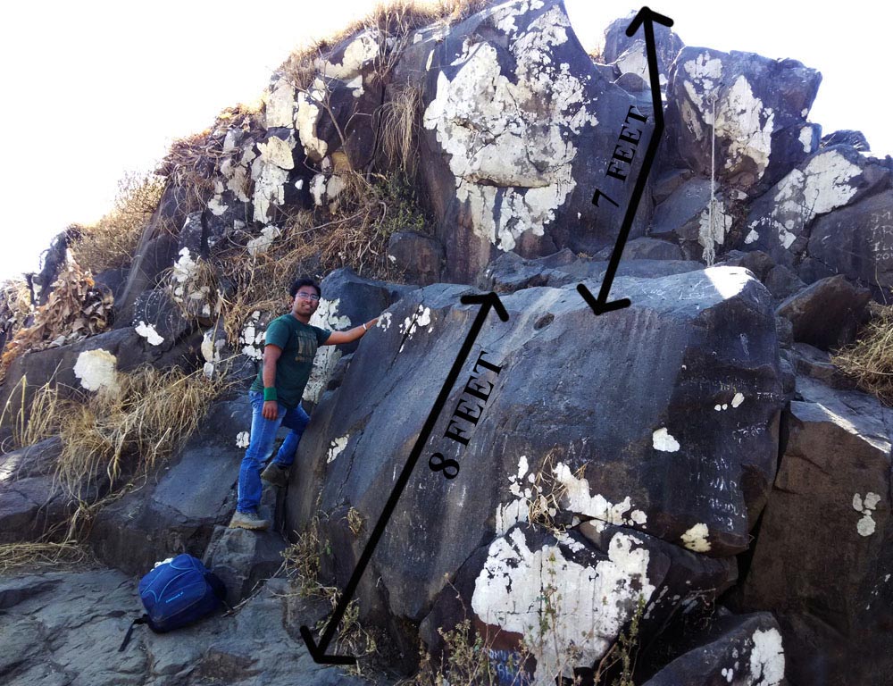
The approach path itself is at an incline and is flanked on both sides by deep valleys. Couple this with half holds, a narrow ledge between the two levels and the rock stands like a gate whose purpose is to make sure that only the ones willing to risk life and limb can gain entry to the hallowed fort that lies behind it.
Find out how we went past this shortcut to hell/heaven, read the Second part!
NOTE:
- All the pictures used in this post have been clicked by me or my friends, unless stated otherwise.
- The information provided in this post is for informational purposes only. Any reliance you place on such information is therefore, strictly at your own risk. For full Disclaimer and Content (including Images) Policy, click here -> Terms of Use.
All rights reserved © 2016 – present Nomadosauras.
Content (including images) not for reproduction in any form, partial or otherwise.
Read complete disclaimer- Terms Of Use.
Cheers!
Keep Trekking

Yessss…
EVEN I FOUND OUT JUST NOW!
😛
And yes… that rock stands like a gate whose purpose is to make sure that only the ones willing to risk life and limb can gain entry to the hallowed fort that lies behind it.
And I did it! (Of course with your help… you made it look so easy!) With those conditions that was looking almost impossible for me!
Hope to see the part 2 soon!
Nice blog!
Keep blogging!
LikeLiked by 1 person
Thank you! 🙂 Part 2 is up as well! check it out from the link above! Keep reading 😉
LikeLike
Thanks for making visualize it all again… Thanks for making such wonderfull trek and a memory as well…
We always knew ur the best leader and now a writer also… Waiting for next blog… Keep blogging…:-D
LikeLiked by 1 person
Thank You Mansi! 😀
LikeLike
Yes.. It needed detailed description.. Well written too.. Happy to see writer in you.. and it surely is just a beginning.. waiting for the next upcoming posts.. and treks too..
LikeLiked by 1 person
Sure thing! 😉
LikeLike
Again and I always say that for you! If anyone is to go for a trek you’ve blogged about, they don’t need to seek information from anywhere else! Description level: Excellent!
LikeLiked by 1 person
Thank you so much! 😀
I sure do hope you visit one of these forts someday! Then maybe I ‘d get to read a post about how you got Peb’d! 😉 😀
LikeLiked by 1 person
Ahahahahshhaha!!! Damn you! Good one! I give in! Ahahahh
LikeLiked by 1 person
😂
But honestly, that picture with the tripod and a plastered hand, that’s badass!! 😅
LikeLiked by 1 person
Hell yeah! It’s that “bhai ka bhabka hai” swag!
LikeLiked by 1 person
😂😂
LikeLike
super post one of the most comprehensive posts on vikatgad/peb fort.thanks for sharing
LikeLiked by 1 person
Thank you so much! Please check out the new posts about other treks published recently 🙂
LikeLike