This is the second part of Chanderi fort trek series. To read Part I- Ascent to Chanderi fort via Tamsai, click here.
Part II
Quick recap: It was 1 pm and I was gasping for breath on the ridge between Chanderi Col and Cave, when I felt a hand on my shoulder.
The Decision:
It was Manish. He had caught up with me and asked if I was okay.
I wasn’t. But I couldn’t tell him that.
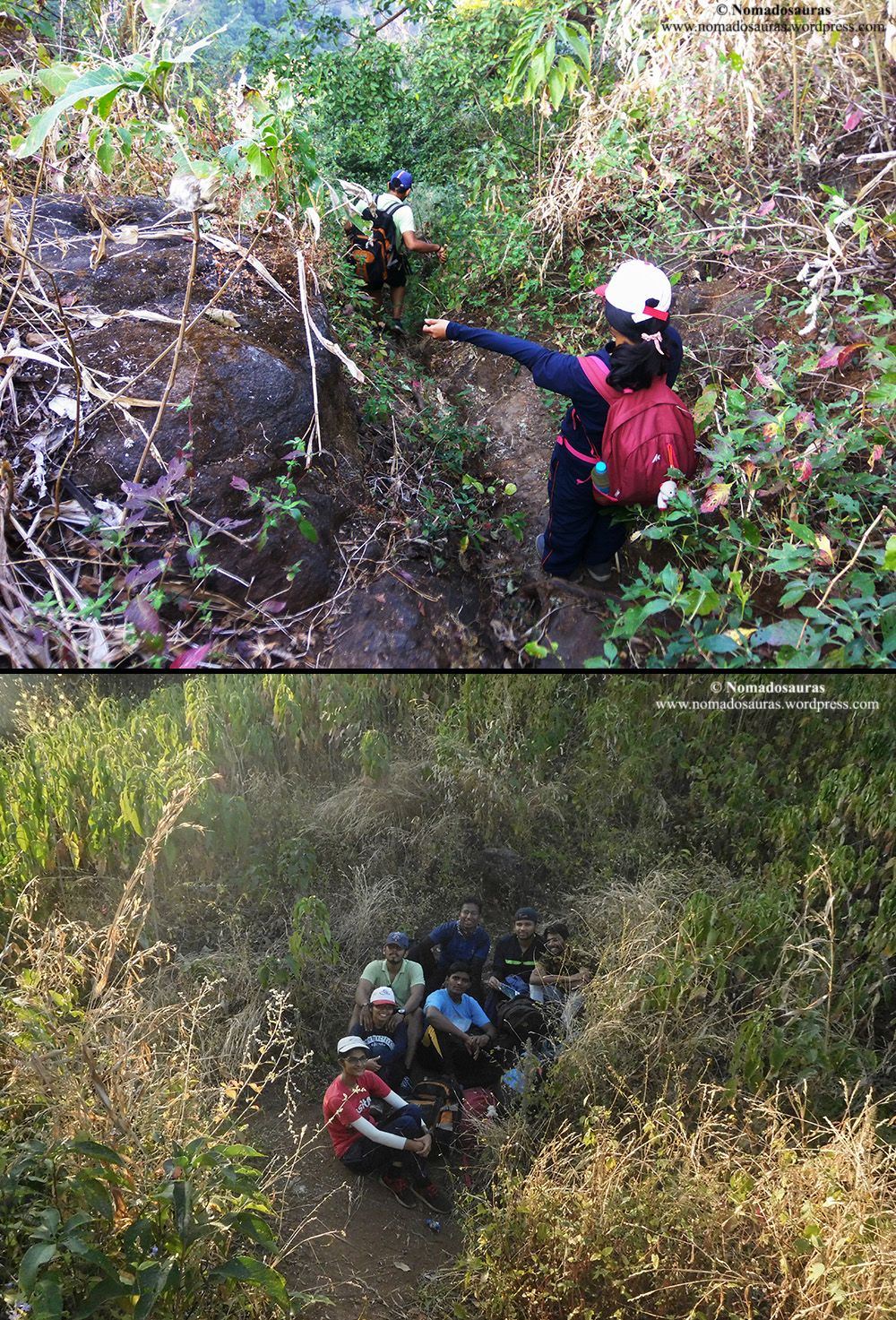
So I asked him to go ahead while I waited for the pain to dull down enough to be able to stand back up. Heart was still pounding away when I finally flicked out my cell phone to check GeoTracker. We were still closer to the col than the cave. Another wave of pain shot through my right leg when I shifted my weight on the steep, narrow trail. If I continued climbing, it might very well set back my ACL recovery by another couple of months. But we have an unsaid rule in the Gang- If one can’t make it, the others won’t proceed either. This meant if I turned back for Chinchavali at that point, others would turn back with me.
I looked back and a few steps behind me was Krunal, who had come for the trek all the way from Gujarat.
Further behind was Darshana, who had been struggling with the heat for a while but continued to climb anyhow.
Tejas was climbing slowly, hauling his huge rucksack with the DSLR in it, probably carrying more weight than the any of us but still chipping away at the mountain with a smile.
Gauri had come to the trek straight from a 6 month-long study course with little physical activity during the period but was climbing admirably well.
Abhi had made it to the trek on the back of another sleepless night.
Shardul too, had come despite being sick only a couple of days back.
And then there was Manish, climbing above me with a foot issue of his own. When all of them continued to climb despite the odds, how could I even think about turning back?
I bent down and felt the knee sleeve- the same sleeve that had helped me pull through the latter 10 kms of Irshalgad-Prabalgad trek despite tearing my ACL. Three months on, I was still in no shape to climb any hill, much less the Chanderi fort. But no one knew this and I wanted to keep it that way. So I had let the sleeve sit at my right ankle under the jeans, ready to pull it up over the knee the moment it started hurting.
And my knee had been hurting for an hour now. But after watching my friends push through issues of their own, the pain no more felt unbearable. I was going to continue but the knee sleeve would stay at the ankle, for now. I would turn to it during the steep descent, if need be.
And with that thought, I pulled up the bandana over my face and started trudging up the ridge.

The Ridge:
The ridge, as mentioned earlier, is a steep climb from the col to the cave with only a couple of flat patches. About halfway up the ridge, a saffron flag flies on the first of these flat rocks, overlooking the Tamsai valley. A little distance above the flag lies the second flat patch with a temple built on top of it. The trail here climbs the shoulder of the ridge to traverse round the rock to end abruptly at the valley.

Fret not! This is no dead end. The trail is instead flanked by two rock walls on either side with the 12 feet high wall on right leading to the temple whereas the 15 feet high wall on the left, is the final obstacle standing between you and the cave. Not wanting to stress my knee for detours, I decided to skip the temple and instead climbed the exposed but easy rock patch along with others.

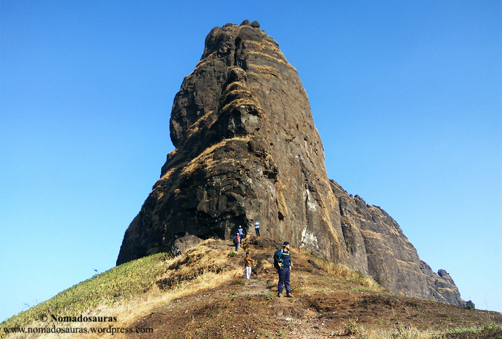
And finally, at half past one, the imposing and rugged Chanderi massif appeared in all its majestic glory!

The Massif:
There are moments that remain etched in your memory long after you have lived them. This is one of them for me.
The distinctive peak I had first seen in 2011 but had remained elusive all this while was finally in front of me. Pictures don’t do justice to the spectacle that is this structure, standing today. And true to its reputation, the wind here was far stronger than anywhere else on the trail, which coupled with the loose, crumbling rocks of the fort can be (and has been) very dangerous.
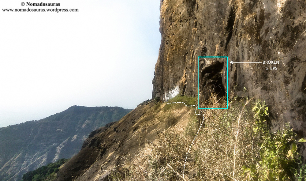
A couple of steps have been roughly carved close to the base of the massif, after which the trail forks out into two with the one on right leading to the cave. I had barely stepped on the trail to cave when my miserable shoes slipped again and the steep, exposed valley on my right suddenly started looking ominous.

Nothing to worry though, a little sure-footedness is all that is needed to stay safe on this section. The trail dips and then rises over a distance of about 100 metres before reaching the white-washed shelter at the base of the rock, known as the Chanderi Cave!
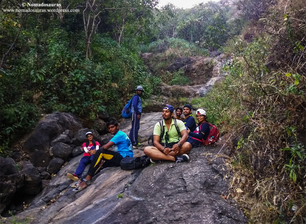
When I walked into the cave, a group of 7 was already having their lunch. Surprised at the sight of a single person trekking to Chanderi, they exchanged glances but then the rest of the Gang entered the cave one after the other and their curiosity was nipped in the bud!
The Cave:
The Cave can be roughly divided into three parts- The cooking area, the sleeping area and the short idol floor. The cooking area is a depression in the western (left side with your back to the valley) part of the cave, so chosen to make sure the flame isn’t put out by the ferocious wind of the region. The sleeping area is a relatively flat rocky floor in the eastern part of the cave, big enough to accommodate 15-20 people whereas the idol floor is a couple of feet above the sleeping floor- a tiled area with a temple and small statuette of Shivaji Maharaj. There is also a beautiful idol of Ganpati, placed on a marble pedestal next to the idol floor.

Keeping the sanctity of the upper floor in mind, my friends took off their shoes and took a short nap on it while I struck up a conversation with the other group.

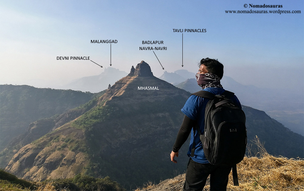
The cave provides a stunning view of the surrounding range stretching all the way from Vikatgad, Matheran, Irshalgad (too faint in picture), Prabalgad to Kalavantin Durg. If the weather’s right, one can even spot Karnala fort, 24 kms away!

Speaking of views, we were greeted by the most unusual of sights a little ahead of the cave- An Indian-style commode with the drainage pipe stretching out into the emptiness! 😛 I have no information about who, when and why chose to build it so close to the cave but from the looks of it, hadn’t (thankfully!) been used since a long time.
Back to the conversation with the other group! They had ascended from Chinchavali and like most trekkers, were going to descend the same way. The group’s leader asked us if we were planning to climb up to the peak, to which I replied in the negative. He pointed to a coil of rope lying at the other end of the cave and said they had tried traversing to the south-eastern end but found it too slippery and exposed for their rope to be useful.
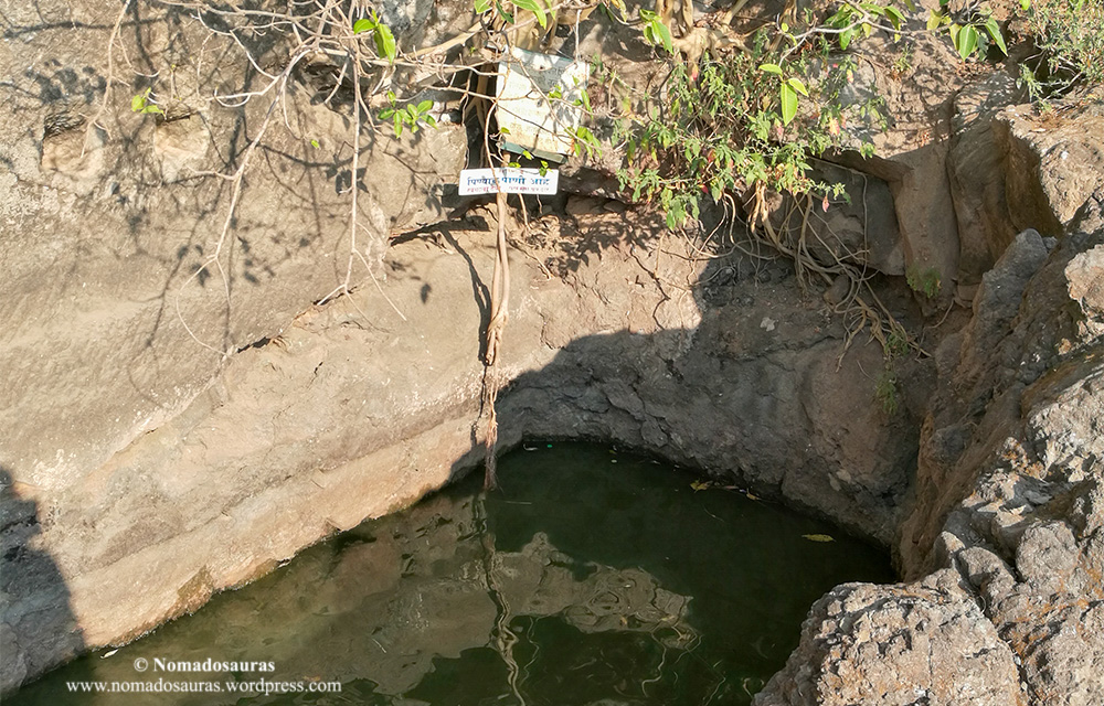
Intrigued by talk of the traverse and at the same time, a little concerned by the dwindling fluid stock left with us, Shardul decided to try and reach the relatively cleaner water cistern at the southern end to refill bottles but returned in some time, confirming that the trail was not in a good shape.

Consequently, we tried checking out the traverse ourselves but my shoes reigned me in, not too far from the cave while Manish went a bit further and managed to click some good pictures of the traverse.
The rest of the Gang was up and about when we returned to the cave and we immediately got down to the most important task of the day- Lunch!

With our rumbling tummies satisfied, we cleaned up part of the cave and clicked the only decent group picture of the day before wrapping things up:

A quarter past four was the time when we left the cave, almost two hours past our tentative schedule. However, what worried me even more was the quantity of water left with us- less than a litre per person despite starting off with three litres in the morning. So we checked out the nearby water cistern once again and even though a thick film of oil (probably from washed utensils) was floating on top of it, we decided to fill some bottles anyway as backup.

With haze no longer obscuring the surroundings, a pleasant blue sky greeted us when we walked over to the western end of the fort!
I could even make out Chinchavali village in the shadows, surrounded by a cluster of smaller hamlets and the sheer distance separating us made me understand the enormity of the task at hand. The wind, as expected, had only gotten stronger since the afternoon and we started our descent cautiously.
The Descent:

If climbing the trail in worn out shoes had been an arduous task, it was nothing compared to the challenge the descent was going to pose. No matter how I placed my feet, my shoes refused to grip the trail, making me descend the steeper sections on my haunches. The trials I have to undergo on trails! 😉

Jokes apart, despite windy conditions, the Gang comfortably negotiated the rock patch near temple and even though the steep ridge proved a little more challenging ‘cos of scree, we swiftly descended to the col by 5 pm.
With little chance of another break during the remaining 4.5 kms (and according to my estimate, about 3 hour) of the trek, we agreed it was best to get equipped for the impending night trek at the col itself and thus came out the printed map of Chinchavali section, torches and what not!
The group from the cave reached the Col at a quarter past 5 and went ahead after giving us a few pointers about the trail. This, for me, is the real essence of trekking- looking out for one another and even complete strangers! 🙂
Back to the trek! The Chinchavali trail is notorious for trekkers losing the way and since we already had had a near-miss earlier that season during the Bhimashankar trek, we decided to stick to a formation ‘cos Chanderi forest isn’t remotely as forgiving to mistakes as Bhimashankar. Being the one most familiar with the trail and landmarks, I was going to lead, followed by Manish, Darshana, Krunal, Shardul, Gauri, Tejas and Abhi, in that order.
The initial section of the trail passes through a steep gully (probably carved by a seasonal stream) for quite some distance before splitting to the right.

But once the trail had deviated from the steep gully, the forest floor posed a couple of problems of its own- the carpet of dry leaves was making our task of choosing the correct trail at forks all the more difficult and on top of that, we also had to be wary of any nocturnal creatures lurking underneath it!
I was constantly looking out for trail markers and arrows that had been mentioned in blog posts and not far from the col, found the first one- a Cairn marker!
A Cairn marker is a column of flat rocks stacked in decreasing size, used to mark the correct trail at diversions. I had barely finished telling Gauri the significance of these markers when a series of dull thuds made me turn back. Tejas, unaware of the stack of rocks being a marker, had gleefully knocked them off! *facepalm*
However, to give credit where it’s due, he promptly stacked them back when we told him it was a marker- an act that I like to believe helped us at a crucial juncture later.
How? Read on!
Nearly lost point#1
From what I had understood after reading the blogs, the route from col to plateau was something like this- the trail first descends through the gully, then splits right before cutting back to its left and finally enters the gully again.
We had been walking along the gully’s right side for quite some time and I was trying to remember if we had missed any diversion when I heard someone call out my name. Lost in my thoughts trying to mentally go over the landmarks, I had somehow missed the arrow indicating the very left turn I was fretting over and had instead sped past it! Thankfully, Darshana spotted it and called out asking me to return to the diversion.
NOTE: This is the first of three points of the Chinchavali trail where we could have easily lost our way but didn’t, all thanks to teamwork.
Back at the diversion, the trail cut onto a flat rock in the gully before crossing over into the forest on the other side. The descent until that point had turned out a little challenging but we had made it through without too much damage, except the odd twist of ankle.
Note: The local trekking groups as well as villagers have done a commendable job of marking the trail wherever possible. You’ll find an assortment of markers- arrows painted on rocks (red and white), cairn markers as also red reflector arrows nailed on the trees! There’s also the occasional ‘Om Namah Shivay’ pasted on trees and though technically not a marker, it can come in handy to find the correct trail at diversions.

Sink or Swim:
We started again after the super short break and as I had read, the trail passed through the forest on its left for some distance and then entered the gully, which gradually opened up into a huge dry basin.
While creating the map for Chinchavali route using Wikiloc trails, I had noticed a peculiar thing- a trail was marked in Google Maps as ‘Chanderi fort trek’ and it deviated considerably from the Wikiloc trail at a crucial section. Not wanting to take an undue risk, I had marked out this particular region in the printed map and at 6.30 pm, when dusk was about to give way to complete darkness, we finally reached it.
With no hint of a trodden trail or even a marker on the barren rocks of the basin except a reflecting arrow that pointed at sheer rock walls in either direction, we decided to fan out. The Google (Maps) trail turned left from the basin at this point whereas the Wikiloc trail went deeper in the basin before turning onto the plateau. I had a hunch that the Wikiloc trail must be the correct one but the basin’s walls were rising steeply from that point onward and a mistake here would have been costly. Our fluid stock was dwindling fast and with no one in Chinchavali anticipating us, help wouldn’t have arrived on its own. If we couldn’t locate the correct trail in fading light, then finding it in complete darkness was well-nigh impossible.

I asked Shardul to check out the forest on left while Krunal went further down the basin and I decided to explore the muddy terrain on our right for any hint of an elusive trail. However, Shardul and I soon returned with dejected faces and were pondering about the next step when Krunal gave a loud call, deep from the basin- He had found a marker! Woohoo!
Can you guess the marker that ‘almost’ saved our lives that day?
Yes! A Cairn marker! Similar to the one Tejas had restacked earlier in the evening. Karma!

The high walls of the basin, towering over 12 feet above us at one point of time, blocked out whatever ambient light was streaming in through the trees and soon we were trekking in pitch darkness. About 10 minutes after passing the cairn marker, the trail split from the basin one last time and entered the forest on plateau.

Note: Please avoid following our itinerary if you are not comfortable navigating through unfamiliar terrain using a map, compass and GPS. Always hire a guide whenever in doubt.
The woods close to the basin were soon replaced by a clear trail cutting through chest-high bushes of the plateau. Aided by the flat terrain, we were breezing through the landscape (and jumping over the occasional puddle) when the trail vanished suddenly and we stopped dead in our tracks.
This is the last of the three ‘nearly’ lost points of the Chinchavali trail.
Nearly lost point#3
The clearing we were standing in had been burnt down by wildfire, leaving behind nothing but a barren, blackened area with no discernible sign of a trail. With no network to check our precise location, we had to rely on our instincts to find a way out.
After walking around a couple of times, we finally spotted the trail re-emerging about 100 metres north of the burnt clearing! I heaved another sigh of relief and had just started walking towards the trail when Darshana’s uncle called up, worried because we hadn’t completed the trek yet.
Using the call as a welcome excuse to rest our exhausted bodies, we plonked down on the plateau only to be astounded by one of the most beautiful scenes I have ever witnessed during treks. Shardul and Tejas brought out their weapons of choice (read: Cell phone on a gorilla tripod & DSLR) and got down to capturing the scene while I volunteered to be the human element in the frame.
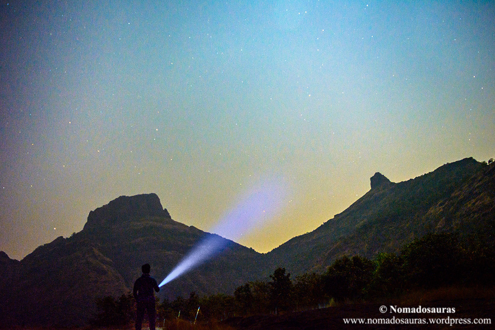
Holding a steady pose for 25 seconds despite aching knee? Meh. Anything for a picture! 😉 Jokes apart, it’s amazing how you can push your physical limits when the circumstances demand it. Even though my right knee was still feeling wobbly, I hadn’t felt the need to pull up the sleeve, helped to some extent by the fact that my body had blocked out pain ever since we had left the gully. Adrenaline most probably.
Coming to the trail, once you have crossed half the plateau, it’s a straightforward path to the base village- whenever it splits, choose the trail pointing north and you are sorted. Once we started walking after the impromptu photography session, Krunal and I tried to push as fast a pace as our bodies would allow at that point of time, dodging everything from the scrambling scorpions, fallen tree stumps and the odd pit to finally reach Chinchavali at 8.30 pm.

The village, as expected, wore a deserted look and we immediately started knocking on the doors to find a ride to Badlapur or Vangani.
There was a vehicle, Autorickshaw/tumtum/van, standing next to almost every house of the village but having retired for the day, no driver was willing to step out again. And right when we had resigned ourselves to walking all the way to Badlapur highway to hitch a ride, one of the men directed us to a house beside which a mini-tempo was parked. We perked up at the thought of an end to our transport ordeal and knocked on the door.
A man came out to tell us that the sole driver of the house had already left for Vangani 10 minutes back, ferrying a group of 7 odd people (the very group we had met in the cave) in their van and would take at least half an hour to return. Boom! There went our 9.04 pm train to CSMT.
After what seemed like ages, he arrived in a Mahindra Maxximo and quoted Rs. 600 for the ride to Vangani. After some bargaining, we brought it down to Rs. 500, still more than what we had paid in the morning for an even longer distance! Nevertheless, we clambered into the back of the van and by the time it screeched to a halt outside Vangani Railway station, the 9.04 pm train had indeed long departed the station.
I limped up the bridge along with others while Shardul, Gauri and Manish somehow found an eatery open at that hour and got food for the journey back home. Incredibly, the local train slithered into the platform on schedule(!) and we made ourselves comfortable in one of its sparsely crowded coaches.
Epilogue:
Tejas and I sat opposite each other while the rest of the Gang occupied seats on the other side of the aisle. As our train accelerated past the sleepy town, the few lights still glowing at that hour turned into a dim blur.
And then my eyes shifted from the black nothingness outside the train to the grinning faces of my friends. They all had had different reasons for climbing the mountain earlier in the day but were smiling now, for a common one.
Me? I was wincing.
With the trek-induced adrenaline no longer blocking pain, my right knee was making me wince every time I shifted a bit. Resigned, I was massaging it through the jeans when someone from the other side of aisle, and I was in too much pain to remember who exactly, said,
“At least now, do not trek again until your knee recovers completely.”
I looked down at my knee and slid the hand down the back of my calf muscle. The knee sleeve was still sitting at the ankle, unused, hidden underneath the jeans.
And my lips twisted into a smile.
“Yeah.” I lied without looking up.
I hope you enjoyed reading about our trek to Chanderi fort. Please let me know your thoughts in the comment section!
If you have any questions about the trek or even suggestions to improve the website, feel free to get in touch using the Contact form. I’ll respond as soon as possible 🙂
If you liked the post, please subscribe to ‘A Season Of Mountains‘ by entering your email ID in the box below and get notified every time I publish a post!
All rights reserved © 2016 – present Nomadosauras.
Content (including images) not for reproduction in any form, partial or otherwise.
Read complete disclaimer- Terms Of Use.
Keep Trekking!

Wow 😱 !, You take lots of effort to write 📝all these. Someday you deserve something(I do know what it is) but, you deserve for writing in detail.
I haven’t read 📰 the whole thing, By scrolling top to bottom literally I need time to read this. Pakka I will get back after reading this.
Keep going … 🏃🏻
LikeLiked by 5 people
Thanks a lot Siva for the constant support and appreciation! 🙂 I look forward to your feedback!
Cheers & Keep exploring 🙂
LikeLiked by 2 people
Wow. Just wow.
Man, your attention to details, sense of humour, style of writing — never cease to amaze me. Thank you so much from the trekking community.
I would also like to repeat the advice. Sincerely, the mountains are not calling!
LikeLiked by 2 people
Thank you so much, Debdutta! Not just for this comment but for being a part of my blogging journey on WordPress!
And I did eventually pay heed to the advice, albeit after another visit to the hills 😉 However, I’ll definitely come back here and revisit this experience and your comment whenever my craving for the hills threatens to get the better of my common sense 😀
Cheers & keep trekking!
LikeLiked by 1 person
Ah, found the comment form! You do spin a tale and do it in style. I would like to see a full-length book by you someday and would love to have an autographed copy too 🙂 Your thoroughness really is impressive and the detailed maps and pointers would be good points of reference for any trekker wanting to answer the call of the mountains. hope your knee has healed well and you are doing more treks with your great gang! All the very best.
LikeLiked by 1 person
Thank you so much for your wishes, M’am! 🙂
The thoroughness comes from all the research that goes into planning a trek and I try to incorporate it in the post to make sure prospective trekkers don’t have to go through the hassle of looking into multiple sources. The maps on the other hand, are the result of my love for cartography and the treks just happen to provide a welcome excuse to create them! 😀
The knee thankfully, is much better now and I am already planning my next sojourn in the hills along with the Gang!
Thanks again for reading the posts so thoroughly and your wonderful feedback 🙂
LikeLiked by 1 person
Wow…just wow! I can totally see you writing a book one day. No one writes such detailed posts and gives out so much information for free.I almost felt guilty for reading this posts without paying you back.
And the picture of the starlit sky with the torch light and everything, that is such a great picture and I wonder how beautiful it must have been to see it live, with your own eyes. It is such a dreamy image, wants me to pack a tent and spend a night there. The view from the cave was mesmerizing as well.
I am short of adjectives to praise your work. As the first commentator said, you my friend deserve something great in life!
Hope your knee is better now. 🙂
LikeLiked by 1 person
Thank you so much for your lovely words, Mona! For a blogger, there’s no greater reward than fellow bloggers (and readers, in general) genuinely appreciating a write-up. 🙂
Chanderi is notorious for people losing their way in the foothills and if this post ends up helping even one person find the way back home safely, there’d be no one happier than me!
And you are right about the picture. As beautiful as it has turned out here, it still pales in comparison to the actual scene. I can only wonder how beautiful the starlit skies of Himalayas would be in person 🙂
As for my knee, it hasn’t recovered completely yet but very close to it. Most importantly, it is no more a hindrance while planning treks so I am not complaining 😀 Finally, I’d like to thank you once again for taking the time to let me know how much you liked the post! 🙂
Cheers!
LikeLiked by 1 person
I should thank you first for reading my long forgotten posts. 🙂
As for the Himalayan night sky, it is beautiful, especially from my hometown. You could see the Pancachuli range from our terrace. I haven’t trekked or traveled much in my own hometown but even a walk to our village back then was an adventure. We didn’t have a road to go that far in those days so we had to walk for hours. I read your “About” page only yesterday and related to the Ruskin Bond quote you have shared. It is as pity that I left the mountains 13 years ago but never have I found peace in the plains. Last year while I was living in Delhi, we went to a day trip to Lansdowne, and as I stepped into the hilly tracts, three words came to my mind, ” I belong here”.
It is great to find a fellow mountain lover over here. 🙂
And seriously, I do hope to read your work on a big platform some day. Best Wishes… 🙂
LikeLiked by 1 person
Your village overlooks the Panchachuli range?!? 😮 How I wish to wake up to a vista like that!
The Ruskin Bond quote in the ‘About’ page is one of the few I treasure for their relevance. And as much as I would like to, I don’t get the chance to trek very often but every time I go back to the hills after a long(ish) break, it feels like I’d never left ‘cos that is where I belong. So I can relate to your Lansdowne experience 🙂
Thank you so much for the wishes! Motivates me to try and be a little more regular with the blog. And that reminds me, it was a pleasure reading your previous posts! You should publish more often too 🙂
LikeLike
Slippery shoes and a hurting knee but nothing can dampen a true trekker’s spirit. I don’t think many people can do this – not me surely! The descend looks quite steep. Descending sucks up all my energy!
Good to know that cairns are used for their real purpose here. I have written sometime back about how its randomly planted anywhere and everywhere and why that isn’t a cool thing to do.
Enjoyed both the posts!
LikeLiked by 2 people
I agree, steep descents can be tough on the body as was the case here till we reached the plateau, maxing out at 54 degrees at the steepest point. I had read about Cairns being stacked randomly on a few trails in North America but didn’t know that is the case in Himalaya as well! 😮 It’s pity that people don’t realise their harmless fun can put people’s lives at risk in worst case scenarios.
Thank you so much for reading the posts and commenting 🙂
Cheers!
LikeLiked by 1 person
Amazing post. It is good that you added correct path, it will help fellow trekkers. We, most of the times, lose trail as there are hardly any sign boards on the way. Lot of work needs to be done in this area. Also you have nicely annotated nearby peaks and forts.
Which camera do you use?
LikeLiked by 1 person
Thank you so much, Gunjan! 🙂
My friends and I try to do our bit during treks by tying ribbons or re-painting faint arrows but that is only possible when we retrace a path during descent, which is quite rare for the treks that we do.
The Nikon S7000 (1/2.3 inch sensor) is our workhorse for treks as it can be charged on the go using a powerbank but it is no longer in production. As for the long exposure photograph, it has been clicked using a Nikon D5200 DSLR 🙂
Thanks again for stopping by and appreciating the post.
Cheers & keep trekking!
LikeLiked by 1 person
Wow 🙌🏻! Your story-telling skills are on point! Tell me you write fiction too?
LikeLiked by 1 person
Glad you liked it! 🙂
I haven’t yet written anything fictional but someday, I might!
And before that, I need to get done with penning my trek experiences, which often are stranger than fiction 😀
Thank you so much for dropping by and the lovely comment as well!
Cheers & keep exploring! 🙂
LikeLike
Really like the way you write. I always want to read more of it 🙂
LikeLiked by 1 person
Thank you Rimika! I have recently published a couple of posts. Do consider checking them out 🙂
Looking forward to reading more from you as well!
Cheers!
LikeLike